

Sutlej River: A Tale of Colourful Heritage is a tale of a magnificent river that is is one of the rivers of Punjab.
Sutlej River originates from Rakshasthal, a lake in Tibet. Its total length is 1448 km and it is the longest of all five rivers which pass through India and Pakistan.
Sutlej is also called Red River in Greek language. Apart from this, its ancient name is Satadree and it is also called the elephant river by the local people of Tibet.
It joins the famous Beas River near Pakistan-India border and enters in Pakistan at the point of Ganda Singh Wala and then finally meets the Chenab River in Bahawalpur.
Read Also
Red Fort: A Chronicle of Muzaffarabad
Origin of Sutlej River
Sutlej river is also called Satadree and serves as an Indus River’s tributary. It originates in Tibet from the glaciers of Himalaya.
The Sutlej river flows through the Himalayan gorges and irrigates an area of up to 900 miles in the state of Himachal Pradesh, ending in the plains of Hoshiarpur district in India.
It goes From here in the form of a large canal, flowing towards the south-west, falls into the river Beas and enters the Pakistani territory in the Kasur district of Pakistani Punjab.
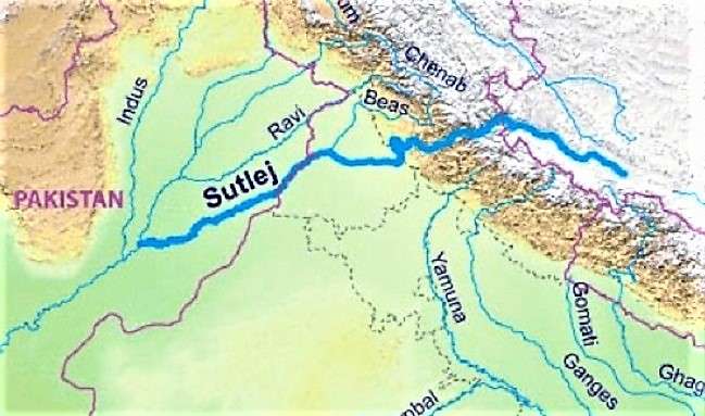
It continues to flow through Bahawalnagar , Bahawalpur, and then it merges with the river Chenab at the place of Panjnad through Uch Sharif.
Moreover, there are a number of canals on the river that are excavated which provide water to the agricultural lands for better production of the crops.
General Information of Sutlej River
Following is the summarized information of the river, including Sutlej River History.
| Title | Description |
| Information | |
| Location: | Between Pakistan and India |
| Type: | Sutlej River |
| Name (Urdu): | درياۓ ستلُج |
| Coordinates : | 29°23′23″N 71°3′42″E |
| Flow Direction | West to Southwest |
| Countries: | Pakistan and India |
| Provinces: | Punjab |
| Cities: | Bahawalpur |
| Left: | Baspa |
| Right -: | Beas |
| Source | Kangrinboqe Peak |
| Location: | Lake Rakshastal |
| Elevation: | 4,575 m (15,010 ft) |
| Coordinates: | 30°50′39″N 81°12′17″E |
| Location: | Bahawalpur district, Punjab, Pakistan |
| Elevation: | 0 m (0 ft) |
| Mouth: | Chenab River to form the Panjnad River |
| Length: | 1,448 km approx |
| Basin: | 395,000 km2 approx |
| Discharge : | Ropar |
| Discharge average: | 500 m3/s (17,657 cu ft/s) |
It is 62 km west of Near Dipalpur the head flows through Sulemanki and irrigates the lands of Bahawalpur and Bahawalnagar districts.
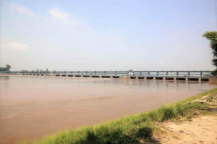
There are two famous barrages on Sutlej river as Sulemanki Headworks near Qasoor district and Islam Headworks near Hasilpur district.
Location
The coordinates of the Sutlej river are 29’23’23” in the North and 71’3’42” in the East. This river flows between India and Pakistan.
Read Also
Thar – Most Fertile Desert of the World
Geography
After originating in Tibet, the water flows through India while forming the Sutlej River which flows through Indian Occupied Kashmir and enters Pakistan.
Before the war between the Sikhs and the British in 1849, this river served as a border. The Sutlej River joins the Indus River at Kot Mithan.
In ancient times, the river Sutlej used to pass near the town of Uch Sharif in Tehsil Ahmedpur Sharqia. Its traces are still there today.
Canals and Dams
The Nawab of Bahawalpur made canals from the Sutlej River to make his state fertile, the water of which is not only irrigating the lands but also used to grow crops in some areas of the Cholistan desert.
Read Also
Colorful Aurora lights over Australia, Norway, USA
Under the Indus Basin Treaty of 1960, India’s right to the water of this river has been recognized. India has built the Bhakra Nangal Dam on the Sutlej River, which generates 450,000 kilowatts of electricity and uses its water for agricultural purposes.
Apart from this, India has made the region fertile by constructing canal projects from the Sutlej River called Sirhind Canal and Sutlej Valley.
The water of this river irrigates agricultural land in the Indian provinces of Punjab, Haryana and Rajasthan.
Water in the Sutlej River from India enters Pakistani territory now only in the form of floods as India uses it as a Flood Release River.


